From "uncertain" to "confident"—East China Sea Navigation Guarantee Center of the Ministry of Transport uses digital innovation to assist "joint governance of commercial and fishing sectors"
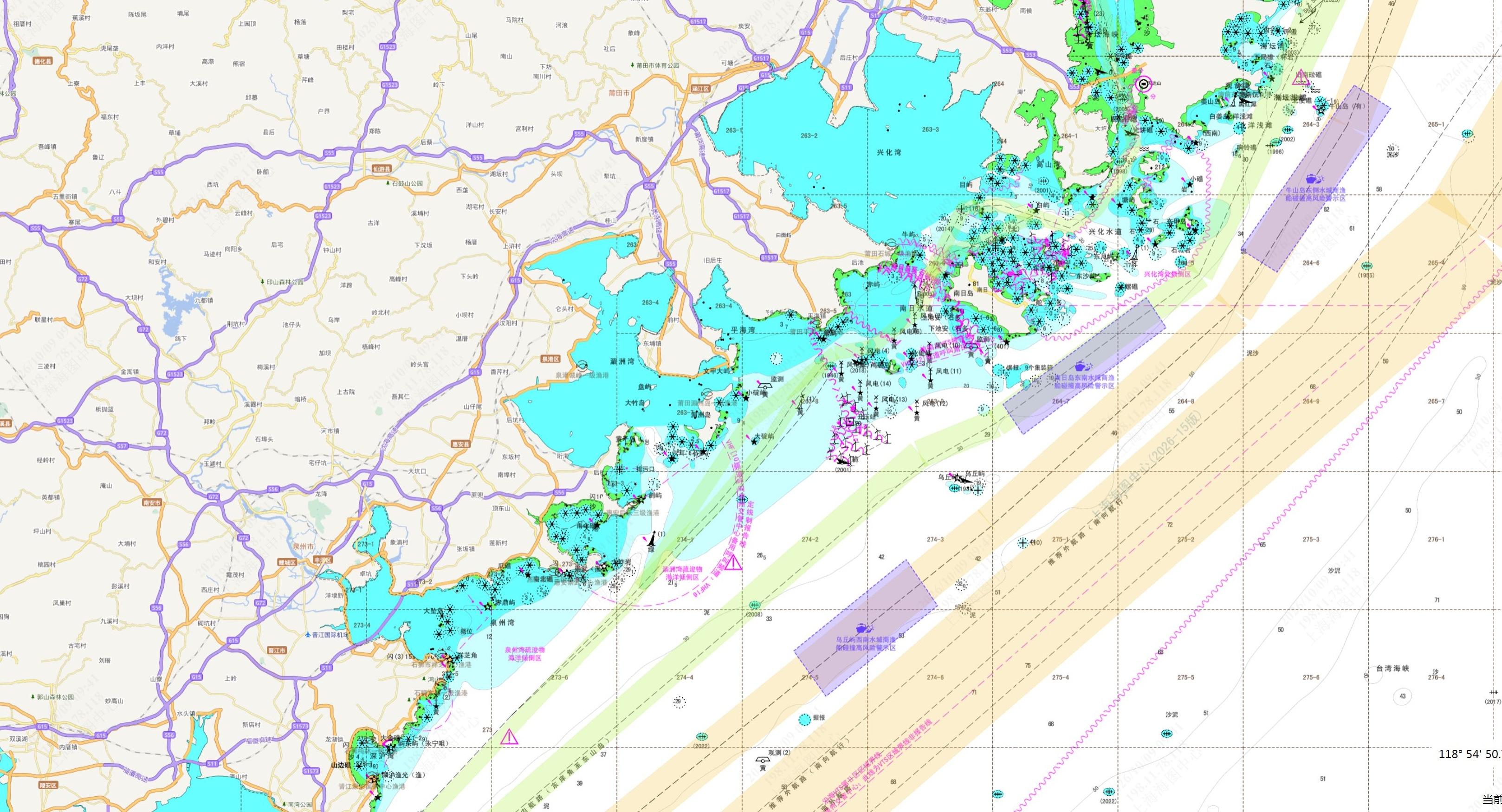
In the cockpit, Captain Yang of the "Hu Chong Yu 12XXX" ship lightly touched the screen, and colorful blocks appeared on the map—purple blocks indicated high-risk collision warning areas for commercial and fishing vessels; yellow lines denoted coastal public shipping routes; scattered icons represented fishing ports and zones. "In the past, when we went out to sea, we couldn’t see which route the commercial ships were taking, and we were uncertain. Now, it’s very clear where the danger is and what to avoid, all on the screen. It makes us feel much more at ease," Captain Yang said with a smile.
What gives the captains their confidence is China's first nationwide electronic fishery thematic chart (referred to as the "fishery chart"). On December 5, 2025, the pilot installation of the first ship was completed at the Hengsha Fishing Port in Chongming, Shanghai. On April 22, 2026, the Shanghai Maritime Safety Administration, East China Sea Navigation Assurance Center of the Ministry of Transport (referred to as the East China Sea Navigation Assurance Center), and Shanghai Municipal Agriculture and Rural Affairs Committee jointly carried out a large-scale promotion and application during the summer fishing moratorium. On October 21, 2026, during the "Maritime Traffic Safety" thematic forum at the North Bund International Shipping Forum, the results of the large-scale installation and application of the fishery chart terminal for commercial and fishing vessels were officially released. So far, more than 4,500 commercial and passenger vessels, along with over 12,000 fishing boats across the country, have been equipped with this chart.
Ensuring Commercial and Fishing Vessels Stay on the Right Path
Collisions between commercial and fishing vessels have long been a significant risk in China's coastal marine traffic safety domain. In line with the Ministry of Transport's deployment to accelerate the construction of a modern navigation assurance system and the special action requirements for "joint governance of commercial and fishing vessels," the East China Sea Navigation Assurance Center has independently developed the fishery chart, which fills a void in the industry. They integrated high-risk collision warning areas for commercial and fishing vessels, coastal public navigation routes, fishing zones, and ports into one cohesive chart using multifaceted data fusion technology and China's official maritime electronic chart as the core data base.
Looking closely at the chart, data is its foundation. The fishery chart includes over 20,000 thematic elements such as fishing ports and grounds and marks 38 high-risk collision warning areas and 359 coastal public routes. Key information for navigation along major north-south sea corridors is also integrated, achieving comprehensive coverage of China's coastal waters. Fishermen can see every route and warning area, each referenced from authoritative sources.
The East China Sea Navigation Assurance Center's research team adhered strictly to the IHO (International Hydrographic Organization) S-57 international standard as the backbone while formulating seven coding specifications based on the actual operational needs of fishermen. This allows navigational safety elements and fishery production features to be displayed simultaneously on the chart with colored differentiation, making safety alert information instantly recognizable.
Authoritative data and standardized coding contribute to the chart's outstanding quality. When opening the fishery chart, high-risk warning zones, recommended routes, and fishing ports and zones are clearly marked. Collision-avoidance information is displayed all on one chart, transforming the institutional requirement for commercial and fishing vessels to "stay in their respective lanes" into a clear on-screen guide. Thanks to innovative practices, this achievement has been awarded the highest prize in China's cartography community—the Pei Xiu Gold Medal—and has become a landmark accomplishment in the digitization of "joint governance between commercial and fishing vessels."
Enabling Authoritative Charts to Be "Ship-Ready"
A tiny error on the chart could lead to a major deviation on the sea. The vitality of a nautical chart lies in its real-time accuracy.
The East China Sea Navigation Assurance Center has established a complete closed-loop mechanism for producing, correcting, and releasing fishery charts, ensuring dynamic updates of chart data in step with the implementation of maritime traffic regulations. For example, during the critical transition phase of implementing the "Liaoning Coastal Ship Routeing System," the center efficiently completed the mapping of the system overview and special chart corrections. They issued correction notices at the first opportunity, synchronously amending overlapping content between the routeing system and public routes on the charts. This ensures that the chart information remains consistent with navigation management regulations, providing solid technical support for precise maritime traffic control in the Liaoning waters.
"Whenever maritime navigation rules are updated, chart data must keep pace. Even the slightest error could mislead ship navigation," said Cao Yuan, Director of the Maritime Surveying and Mapping Department at the East China Sea Navigation Assurance Center.
Data must remain updated, and the charts must reach the vessels. The East China Sea Navigation Assurance Center provides standardized chart data to equipment manufacturers and has established a regular data synchronization mechanism. New factory-produced equipment can be pre-installed with the latest charts, and vessels with existing equipment can obtain the newest data through online upgrades.
With diverse types of navigation equipment and varying standards across vessel types, achieving terminal compatibility is a key aspect of implementing the chart. Given that most fishing vessels are equipped with plug-in AIS (Automatic Identification System) devices, the East China Sea Navigation Assurance Center collaborated with relevant equipment manufacturers to tackle multi-terminal technology challenges. They ensured coverage for commercial vessel ECDIS (Electronic Chart Display and Information Systems), onboard ECS (Electronic Chart Systems), fishing vessel plug-in AIS, and onboard Beidou positioning and navigation terminals. The resulting deployment plan aligns closely with the operational realities of fishing vessels and crew habits. A differentiated approach was innovatively developed: commercial ship terminals prioritize "online delivery with offline installation as a supplement," while fishing vessel terminals focus on "factory pre-installation with stock upgrades as a secondary option." This approach overcomes compatibility challenges and achieves "ready-to-use" functionality—for all types of terminals, they recognize the same chart.
The summer fishing moratorium is a golden opportunity to advance large-scale implementation. During this period, when fishing vessels are docked at ports, the East China Sea Navigation Assurance Center, in cooperation with maritime and fishery departments, forms dedicated teams to conduct on-site upgrades and debugging, seizing the opportunity for centralized installation and significantly improving implementation efficiency. Within the collaborative model of "center releases data—manufacturers integrate for compatibility—terminals install and apply," large-scale application of the fishery chart has been fully promoted. Commercial vessels have been adapted to several major brand terminals, with installation and upgrades completed for over 4,500 commercial and passenger vessels. On the fishing vessel side, a pilot-first approach has led to installations on 157 of the 166 registered fishing vessels in Chongming, Shanghai. Through manufacturer-driven factory pre-installations, regions such as Liaoning, Shandong, Jiangsu, Zhejiang, Fujian, Guangxi, and Guangdong have completed installations on over 12,000 fishing vessels. With simultaneous efforts on both commercial and fishing vessels, a large-scale application framework is taking shape.
With the chart installed on their vessels, how effective is it? The crew members have the most to say.
"Now, the high-risk warning areas are clearly marked on the chart, allowing us to plan routes in advance and slow down to avoid risks ahead of time. I feel much more confident," one commercial ship captain remarked with praise.
Today, with just a tap on the terminal in the cockpit, risk zones along the route are visible in advance. Crew members are prepared, know their course, and proactively avoid risks. Safe navigation is becoming a habit. A single screen has become the "peace of mind" for sailors venturing out to sea.

Providing Support for Maritime Governance
A chart is not only the "eyes" of the crew but also an effective tool for maritime regulation.
The East China Sea Navigation Assurance Center has promoted the integration of the fishery chart into the Maritime Services App, the intelligent maritime regulatory platform, and the fishery department's "Watchmen" coastal intelligent monitoring system. This integration enables a holistic view of dynamic commercial and fishing vessels and high-risk zones on a single screen. "In the past, we mainly relied on sending notifications or making phone calls to remind commercial ships to avoid fishing areas. Now, high-risk zones, fishing ports, and fishing zones are clearly visible on the platform, making warnings more accurate and handling more efficient," said Ye Xiao, a staff member from the Shanghai Maritime Safety Administration's Safety Division. "The fishery chart has provided a tangible digital tool for 'joint governance between commercial and fishing vessels.'"
With vessels able to avoid risks and shoreside authorities equipped for oversight, the fishery chart promotes two-way empowerment, aiding maritime safety governance transition from "human defense" to "human defense + technical defense." Building on this foundation, the East China Sea Navigation Assurance Center has launched a function on China’s Maritime Nautical Charts Online Service website for publishing fishery thematic electronic charts, ensuring direct service to ship captains.
The chart’s stage is not limited to ship decks. Based on this project, the East China Sea Navigation Assurance Center has drafted the "Fishery Thematic Electronic Chart Product Specification," initiated the compilation of a proposal to add "commercial-fishing vessel collision high-risk warning zones" as new elements to the S-101 electronic chart, and is paving the way for applying for industry and national standards, while actively advancing registration with IHO's geographic information registry.
"To ensure the product has a global reach, the standard must take the lead," said Cao Yuan. "We not only aim to solve domestic issues concerning collision avoidance between commercial and fishing vessels but also to actively participate in setting international standards, striving for a voice in global governance of commercial-fishing vessel safety and contributing China’s solutions."
From breaking down a "wall of information" to weaving a "safety net," and further to contributing a "China solution," the practice of leveraging digital innovation to support "joint governance between commercial and fishing vessels" is extending from the shores of the East China Sea to all of China's coasts.
In the future, the East China Sea Navigation Assurance Center will continue to iterate on the fishery thematic electronic chart product system, deepen its application, and enable more commercial and fishing vessels to use the chart, ultimately transforming technological advantages into a protective barrier for maritime safety and strengthening coastal maritime traffic safety along China's shorelines.
-
From "uncertain" to "confident"—East China Sea Navigation Guarantee Center of the Ministry of Transport uses digital innovation to assist "joint governance of commercial and fishing sectors"3184
-
The Dalian Seafarer Skills Competition successfully held.4946
-
The Yangtze River Nanjing Navigation Bureau addresses abnormal navigation marker hazards in the bridge area.3265
-
Tianjin Xinang Maritime Safety Administration organized a seminar to discuss safety management of ship-loaded break-bulk cargo.3880
-
"Study on the Planning of Inland Waterways and Port Layout in Liaoning Province" Approved through Expert Consultation3410